


The star maps with a flat horizon drawn by Wil Tirion
—
a class of their own!
Drawing star maps with a flat horizon
—
not at all an easy computer job
For 2001, 2002 and 2003, the Dutch version “Sterren- en Planetenkalender” has been translated for our publication “Star and Planet Almanac 2003”.
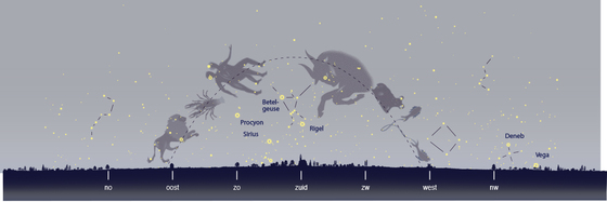
Making horizon maps with a flat horizon with equal distances between NE-E, E-SE and so on, demands a lot of knowledge of projections. A delicate question is, how to get all over the map the distortions as small as possible? You need experience to overview the whole process.
A map with a flat horizon has as a big advance: you recognize at the sky the positions of the constellation of the zodiac quite soon. You do not have to turn a map to the left or to the right.
The publisher of the English version wanted to receive the original Adobe-Illustrator maps 2003 for checking the English names of the stars and constellations. He cancelled the 2004-version and made for 2005 a simple kind of copying. When we discovered this and went to his office, he agreed plagiarism. The production did just happen when he was away.
For 2006 and later years he made “his own version”. But: they were drawn for with the same latitude of our maps, for 52 degrees Amsterdam. He didnot choose e.g. Greenwich, but Birmingham, one of the UK’s city’s with the highest air pollution levels. Birmingham doesnot have a good sky.
The copying was more cunning: our 12 midnight star maps were used for his 22 o´clock maps one month later.
having an older version of the figures of the zodiac
Our midnight map of December was the groundwork of his Januar map for 22 o´clock. Exactly the same stars are in the south, the same stars are rising and setting, exactly the same stars in the south.
We wrote the publisher a letter about the way he did make his "new" publication.
* Your January evening map for 22 o´clock is an exact copy of our December midnight map. The same stars are culminating in the south, the constellations high in the south have the same distortion. The same stars are rising and setting on this moment.
Your February evening map for 22 o´clock is an exact copy of our January midnight map. Once again: The same stars are culminating in the south, the constellations high in the south have the same distortion. The same stars are rising and setting at the same moment.
* The “12 evening maps for 22 o´clock” from his “Stargazers' Almanac: A Monthly Guide to the Stars and Planets 2005”, do have exactly the same star times and exactly the same projections as our 12 midnight horizon maps.
Observations from Wil Tirion
Wil Tirion was very cooperative, he wrote to the publisher:
“The selection of the stars (which is very personal) is also the same. In other words, your map shows the same number of stars that our map shows. For maps like these I never use an exact magnitude cut-off, but usually I show all stars down to a certain magnitude, and then add selected fainter stars to complete some constellations or interesting star groups. Your charts show exactly the same selection of stars.
Besides that, even the symbols used for the stars are the same, although they seem to be scaled somewhat.
Last, but not least, in many places, where stars tend to clutter, because they are too close together, the stars have been moved away a little from their real positions, and again, this is a personal and deliberate inaccuracy, to keep those small groups easy to recognize in the sky. Your map shows exactly the same shifts in some stars positions.”
A worse copy of the original star maps
Wil Tirion gave a detailed description with convincing arguments for plagiarism. What did the English publisher after getting to know distinctive features from a professional Uranograf? He changed these distinguishing characteristics by making a worse copy of the original star maps from Wil Tirion:
* Some stars disappeared, others were added, and some stars were moved a little, all quite arbitrarily. A logical concept for his adaptions couldn't be found.
* The horizon was put down a little lower: the stars were a little higher above the horizon.
* The length-width ratio was changed. The distortion of the constellations high in the south does increase still more.
* A lot of other easily-to-do adaptations, like moving the horns of the bull in another direction.
His publication of 2007 showed much more little differences as his publication from 2006. So his business could go on. He published about fair trade, was an expert in knowing the boundaries of the law.
Nobody managed to make better star maps with a flat horizon
After some years, the publisher made an agreement with another English publisher, who is more familiar with publishing astronomical books. He just went on with these curious Birmingham-star-maps. August 2024 you can find on the internet his advertising, showing the star map of January 2025 for 22 o´clock. He also didn't investigate in star maps that are much more suited for the United Kingdom and the United States than our Amsterdam star maps with a latitude of 52 degrees.
Showing evening map for 22 o´clock the whole year through implicate that Venus and Mercury are very seldom depicted. Venus can just in the lightest months of the year be given the right position between the stars. It is impossible to draw Mercury on a map.
Starting observers do not see the mess with shifts, they are happy with "Great monthly visual of how to find the planets and moon phases".
***
In 2017, there was another plagiarism, in the German language, by using the equal distances of our flat horizon maps. Wil Tirion was surprised how very inconsistent the displaced stars and the distorted constellations were.
***
These two plagiarisms were a wake-up call: the star maps drawn by Wil Tirion are a class of their own!
